- Printed Journal
- Indexed Journal
- Refereed Journal
- Peer Reviewed Journal

Subscribe Print Journal

Zoological Record Indexing

Important Information
- Helpline for Authors
- India: +91-9711224068
- Toll Free: 1800-1234070
- Working hours 10:00 AM-06:00 PM
Issue Bar
Open Access
Side Bar
Identifier

Vol. 1, Issue 3, Part A (2014)
Spatial cognition: a geospatial analysis of vector borne disease transmission and the environment, using remote sensing and GIS
Author(s): M. Palaniyandi, PH Anand and R. Maniyosai
Abstract: Materials and Methods: The data pertaining to vector borne diseases were collected and was attached to the district map using Arc View 3.2 GIS platform (ESRI, NIIT-Chennai, India) for preparation of disease prevalence in India. The district wise thematic information of geo-climatic variables (Mean Annual Temperature, Mean Annual Rainfall, Relative Humidity, Saturation Deficit, Altitude, Soils types and Population density), vector borne diseases were developed and the data set was imported into SPSS+ for geo-statistical analysis. Remote sensing and GIS is has the important role in the ecological mapping of vectors breading habitats. Remote sensing of IRS LISS I and LISS II data products were analyzed, using ERDAS Imagine 8.5 and was integrated into GIS for spatial analysis for classification. The integrated hybrid remote sensing and GIS techniques have been used to mapping the vector breeding potential areas vulnerable to risk of disease transmission. Conclusion: The study has made for analyzing the spatial agreements between the environmental variables and vector borne disease transmission in India, and perhaps, the appreciation of GIS in the spatial and the ecological aspects of vector borne diseases towards the achievement of vector borne disease transmission control in India. and thus, the remote sensing and GIS has been provided the guidelines to choose appropriate control strategy and mapping disease transmission risk zones based on the information derived from the geo-statistical analysis of environmental variables in the country.
Related Graphics: Click here for more related graphics
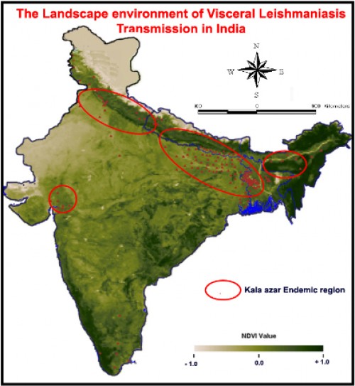
Fig.: The Visceral Leishmaniasis / Kala-azar endemic data is overlaid on the mean NDVI; value; map of IRS WiFS data of India, the geographical distribution of Visceral Leishmaniasis is spatially associated with mean composite NDVI value range between; 0.08 - 0.53, (95% significance and; 5%; error precision with confidence interval, CI- 0.413 -0.544), p value <0.001. Source: M.Palaniyandi, et al., 2014
Pages: 39-54 | 2359 Views 175 Downloads

How to cite this article:
M. Palaniyandi, PH Anand, R. Maniyosai. Spatial cognition: a geospatial analysis of vector borne disease transmission and the environment, using remote sensing and GIS. Int J Mosq Res 2014;1(3):39-54.
Zoological Record Indexing
Important Information
- Helpline for Authors
- India: +91-9711224068
- Toll Free: 1800-1234070
- Working hours 10:00 AM-06:00 PM
Issue Bar
Open Access
Side Bar
Identifier
Related Links

International Journal of Mosquito Research