Vol. 1, Issue 1, Part A (2014)
A geo-spatial modeling for mapping of filariasis transmission risk in India, using remote sensing and GIS
Author(s): M. Palaniyandi
Abstract: The study was designed for mapping the filariasis transmission risk using geo-climatic variables. The application of remote sensing and GIS in the present study is mainly focused on profiling the areas at risk of filariasis transmission. The filariasis disease is caused by the Culex genus mosquito vector. The survival and longevity of infected filariasis vector mosquitoes are spatially determined by the geo-climatic variables. The geo-climatic variables are contiguous in nature, to relate the filariasis endemicity (mF and disease), a spatial interpolation or Kriging could provide the predicted surface of filariasis transmission in the areas where no information is available or areas at remote and difficult locality where to conduct a survey is not possible. Therefore, the geo-statistical analysis of GIS spatial interpolation or Kriging method was applied for obtaining the values for constructing the continuous surface of predicted filariasis surface for stratification of the areas for mapping of filariasis endemicity with accuracy of 93.4% statistically significant and sensitivity of 97.6% (95% confidence interval). The geo-statistical predictive model shows that the observed value of the filariasis prevalence and the predicted value of filariasis surface were correctly classified with statistically significant and perfectly fit on the predicted surface of the filariasis risk zones. The geo-statistical analysis was applied for establishing the spatial autocorrelation between the geo-climatic variables and the surface map of predicted filariasis risk zone which is statistically significant with 72.3% accuracy. The predicted map of filariasis transmission risk zone is useful for decision making and choosing the appropriate control strategy for implementing the filariasis control program in India where the filariasis transmission risk is high and moderate.
Related Graphics: Click here for more related graphics

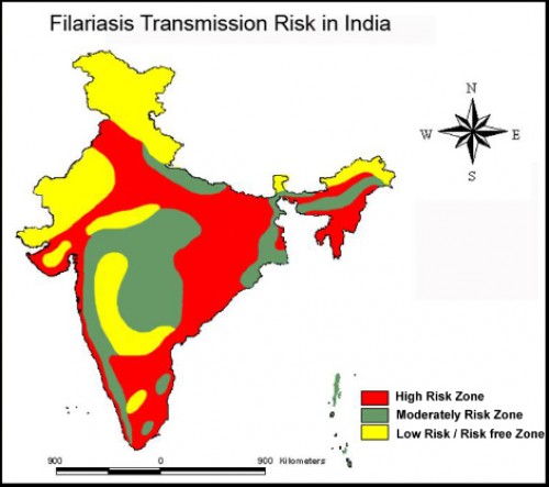
Fig.: Filariasis Transmission Risk Zones in India, based on climate, landscape and the environmental variables.
Pages: 20-28 | 2056 Views 240 Downloads

How to cite this article:
M. Palaniyandi. A geo-spatial modeling for mapping of filariasis transmission risk in India, using remote sensing and GIS. Int J Mosq Res 2014;1(1):20-28.


