The application of geographic information system (GIS) to assess the population abundance of Aedes albopictus (Skuse) in mangrove forests of Penang, Malaysia
Author(s): TN Saffawati, T Ismail, Nur Faeza A Kassim, Azimah Ab. Rahman, Suhaila Ab. Hamid, Khairun Yahya and Cameron E Webb
Abstract: Mangrove forests in Malaysia represent ecosystems containing a variety of flora and fauna species. Mosquitoes are common in these habitats and known vectors of mosquito-borne pathogens, an understanding of the abundance and distribution of mosquitoes in mangrove forests assists the assessment of potential disease outbreak. The mangrove environments are physically challenging to survey due to extensive muddy flats and frequent tidal inundation so limits the opportunities to study the mosquito populations. The focus of the study is to assess the risk of mosquito borne pathogen transmission at Pulau Betong, Balik Pulau, Penang by mapping the distribution of known vector species found in mangrove habitats by using ovitrap data incorporated into Geographical Information System (GIS) analysis. The study found that over a six month period, the activity of Aedes albopictus, peaked in August and October before a drastically droping in early November due to the onset of the dry season.
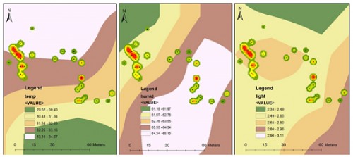
 Fig.:
Fig.: Spatial interpolation on population density of
Ae. albopictus in relation to temperature, humidity and light intensity in study area.The data of meteorological parameters are interpolated to population density of
Ae. albopictus using inverse distance weighted (IDW). (Source: ArcGIS 10.3 software).
How to cite this article:
TN Saffawati, T Ismail, Nur Faeza A Kassim, Azimah Ab. Rahman, Suhaila Ab. Hamid, Khairun Yahya, Cameron E Webb. The application of geographic information system (GIS) to assess the population abundance of Aedes albopictus (Skuse) in mangrove forests of Penang, Malaysia. Int J Mosq Res 2019;6(1):50-54.


