- Printed Journal
- Indexed Journal
- Refereed Journal
- Peer Reviewed Journal

Subscribe Print Journal

Zoological Record Indexing

Important Information
- Helpline for Authors
- India: +91-9711224068
- Toll Free: 1800-1234070
- Working hours 10:00 AM-06:00 PM
Issue Bar
Open Access
Side Bar
Identifier

Vol. 4, Issue 4, Part B (2017)
Mosquito larval habitat mapping using remote sensing and GIS for monitoring the filarial infection regions in Alkorin village, Sharkia Governorate (Egypt)
Author(s): Arafa N El-Naggar, Shereen M Elbanna, Mona F Kaiser and Refaat M Gabre
Abstract: No doubt that the mosquitoes are the main vector for many fatal human diseases, such as malaria, filariasis, and several arboviral diseases. Mosquito Culex (Culex) pipiens L. implicated as a vector of filariasis in Alkorin Village, Sharkia Governorate (Egypt). Potential larval habitats of mosquito were identified using integrated remote sensing (RS) and geographic information system (GIS) analyses during successive two years (2015- 2016). Mapping mosquito breeding habitats were the basis for management and control of endemic filariasis transmitted by Culex mosquitoes. By using satellite image digital data and GIS, maps for the temperature, salinity, turbidity and mosquito larval habitats of the study area were constructed. Data analyses show clear effectiveness of temperature and turbidity on the abundance of the mosquito larvae. Consequently, the distribution density of the filariasis on the study area modeled using GIS. The optimum water temperature for the highest larval growth rate ranged from 27 to 33 oC and turbidity was ranged from 5 to 145 NTU. Meanwhile, salinity ranges had no effect on the abundance of mosquito larvae. In conclusion, remote sensing and GIS technologies with computer modeling are useful tools in providing a solution for future disease eradication planning and management to government especially in formulating policy related to the mosquito and disease control.
Related Graphics: Click here for more related graphics
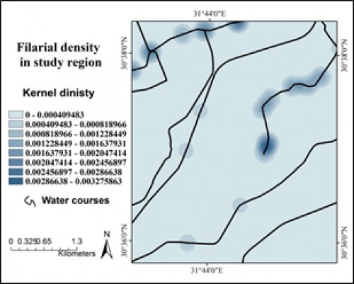
Fig.: Modeling of filariasis density in study region.
Pages: 135-139 | 2490 Views 274 Downloads

How to cite this article:
Arafa N El-Naggar, Shereen M Elbanna, Mona F Kaiser, Refaat M Gabre. Mosquito larval habitat mapping using remote sensing and GIS for monitoring the filarial infection regions in Alkorin village, Sharkia Governorate (Egypt). Int J Mosq Res 2017;4(4):135-139.
Zoological Record Indexing
Important Information
- Helpline for Authors
- India: +91-9711224068
- Toll Free: 1800-1234070
- Working hours 10:00 AM-06:00 PM
Issue Bar
Open Access
Side Bar
Identifier
Related Links

International Journal of Mosquito Research