Vol. 1, Issue 3, Part A (2014)
Web mapping GIS: GPS under the GIS umbrella for Aedes species dengue and chikungunya vector mosquito surveillance and control
Author(s): M. Palaniyandi
Abstract: The mosquito nuisance and the mosquito borne diseases have become major important challenging public health problems in India especially in the fast developing city like Pondicherry urban agglomeration. The Pondicherry government has been implemented full-fledged mosquito control measures, however, dengue and chikungunya epidemics was accelerating trend in Pondicherry for the recent years, and therefore, the directorate of public health, Pondicherry was requested vector control research centre (VCRC), to conduct a mosquito control evaluation survey. A team of field staff of VCRC headed by the author, Pondicherry, have conducted a detailed reconnaissance survey for collecting the site specifications of houses and the streetwise mosquito data for analyzing the density of vector mosquitoes in the wards / blocks and delineating the areas vulnerable to disease epidemics in the urban areas. The GPS GARMIN 12 XL was used to collect the field data. The ARC GIS 10.0 software was used to map the site locations (houses) with mosquito’s data. The digital map of block boundary of Pondicherry was used for mapping purpose. A systematic grid sampling was applied to conduct a rapid survey for mapping Aedes species mosquito genic condition in the urban areas and the coordinates of sites of house information with breeding habitats positive in the grid sectors was collected using GPS, and the mean value of positive habitats was analyzed by quintiles method for mapping. The four blocks were selected for Aedes mosquito survey where the mosquito problem was identified as comparatively high, four numbers of wards were selected from each block, and the 40 number of houses was selected with 100 meter interval distance for mosquito breeding survey in the domestic and peripheral domestic areas in each wards. The problematic areas were identified, highlighted and recommended for web mapping GIS for Aedes mosquito surveillance continuously for monitoring the mosquito control measures in the Pondicherry urban areas and the other parts of the urban areas in the country.
Related Graphics: Click here for more related graphics

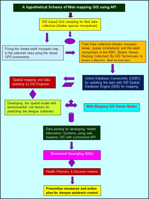
Fig.: The internet GIS mapping for prediction and prevention of dengue & chikungunya epidemics
Pages: 18-25 | 2416 Views 350 Downloads

How to cite this article:
M. Palaniyandi. Web mapping GIS: GPS under the GIS umbrella for Aedes species dengue and chikungunya vector mosquito surveillance and control. Int J Mosq Res 2014;1(3):18-25.


