
"International Journal of Mosquito Research"
Vol-1, Issue-3
Spatial cognition: a geospatial analysis of vector borne disease transmission and the environment, using remote sensing and GIS
M. Palaniyandi, PH Anand and R. Maniyosai
Background: The prevalence of geographical distribution of vector borne diseases has been increasingly public health important and challenging problems in more than 100 tropical countries and it has been affecting more than 50% of the population in the world, especially, it is very big problem in India. The change of vector borne disease epidemic transmission in to the endemic situation in the country has been caused by the land use / land cover changes, regional climate changes, increase of sea change population, urban agglomeration, industrial development and the past development of towns, consequently, the disease epidemics have been steadily increased too, and, besides, it has been found ubiquitous, such diseases known as, malaria, filariasis, JE, dengue and chikungunya, as a result, the increase of both mosquito nuisances and disease transmissions has become public health importance and very big challenging problems in India.
Materials and Methods: The data pertaining to vector borne diseases were collected and was attached to the district map using Arc View 3.2 GIS platform (ESRI, NIIT-Chennai, India) for preparation of disease prevalence in India. The district wise thematic information of geo-climatic variables (Mean Annual Temperature, Mean Annual Rainfall, Relative Humidity, Saturation Deficit, Altitude, Soils types and Population density), vector borne diseases were developed and the data set was imported into SPSS+ for geo-statistical analysis. Remote sensing and GIS is has the important role in the ecological mapping of vectors breading habitats. Remote sensing of IRS LISS I and LISS II data products were analyzed, using ERDAS Imagine 8.5 and was integrated into GIS for spatial analysis for classification. The integrated hybrid remote sensing and GIS techniques have been used to mapping the vector breeding potential areas vulnerable to risk of disease transmission.
Results and Discussion: The result shows that the possible information on reliable estimates of and mapping of malaria, filariasis, JE, and dengue vector breeding habitats, and facilitate to estimate the people at risk of vector borne disease transmission. The results of the present research study shows that spatial agreement was existed between the environmental variables and the vector borne disease epidemic transmission. The geographical distribution and the seasonal abundance of vector abundance and vector borne disease transmission have completely been controlled by the climate, landscape and the environmental variables.
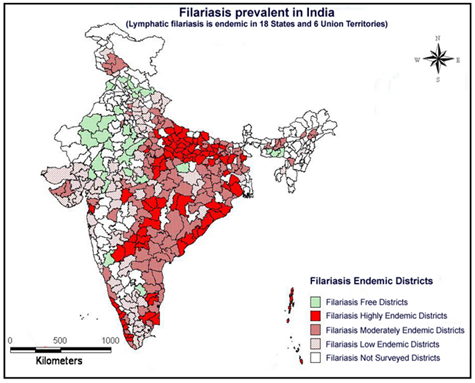
Fig: Filariasis Endemics in India as on 2012, source: M.Palaniyandi, 2014
Download Full Article: Click HereClick Heresee