- Printed Journal
- Indexed Journal
- Refereed Journal
- Peer Reviewed Journal
Subscribe Print Journal

Zoological Record Indexing

Important Information
- Helpline for Authors
- India: +91-9711224068
- Toll Free: 1800-1234070
- Working hours 10:00 AM-06:00 PM
Issue Bar
Open Access
Side Bar
Identifier

Vol. 3, Issue 3, Part A (2016)
Assessment of malaria high risk areas by using RS & GIS technologies in Rohtak and Mewat districts of Haryana
Author(s): Amrita Kumari and Rajni Kant
Abstract: The presence of mosquito vectors Anopheles culicifacies and Anopheles stephensi in high numbers together with other malaria causing factors like poor drainage system, lack of knowledge about malaria, low socio-economic conditions etc has made malaria a major health burden in Rohtak and Mewat districts of Haryana. The primary objective of the study was to prepare thematic maps of six selected villages of Rohtak and Mewat districts for the year 2008 and 2013 by using RS & GIS technology. High Annual Parasite Incidence (API) of the village Kalanaur (3.48) in Rohtak district and village Ujina (5.1) of Mewat district was directly correlated to the number of water bodies with indication of favourable conditions for the breeding of anopheline mosquitoes in the respective villages. Hence, the present study identifies the risk factors associated with high malaria transmission in six selected PHCs of Rohtak and Mewat districts of Haryana and help to plan focused malaria control interventions to combat malaria transmission.
Related Graphics: Click here for more related graphics
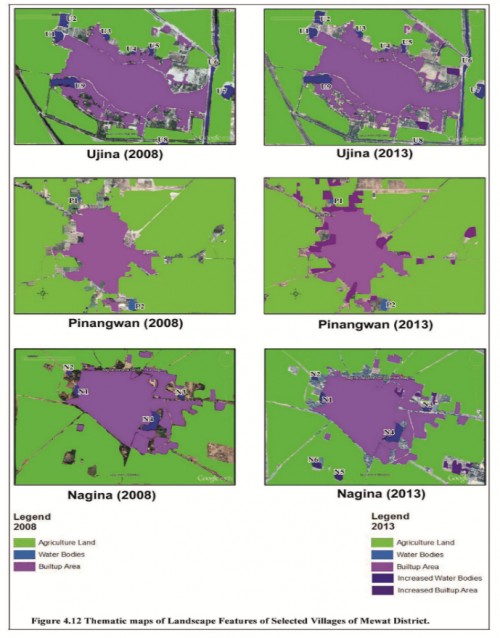
Fig.: Thematic maps of Landscape Features of Selected Villages of Mewat District.
Pages: 51-53 | 2064 Views 82 Downloads
How to cite this article:
Amrita Kumari, Rajni Kant. Assessment of malaria high risk areas by using RS & GIS technologies in Rohtak and Mewat districts of Haryana. Int J Mosq Res 2016;3(3):51-53.
Zoological Record Indexing
Important Information
- Helpline for Authors
- India: +91-9711224068
- Toll Free: 1800-1234070
- Working hours 10:00 AM-06:00 PM
Issue Bar
Open Access
Side Bar
Identifier
Related Links

International Journal of Mosquito Research